Severe Thunderstorms Threaten Texas With Softball-Sized Hail, 80 MPH Winds, Flooding and Possible Tornadoes
Key Takeaways
- Severe thunderstorms will impact many Texas regions today, tonight, and Wednesday
- Threats include softball-sized hail, 80 mph winds, flooding, and isolated tornadoes
- Severe thunderstorm watches and flood advisories cover multiple North Texas counties late tonight
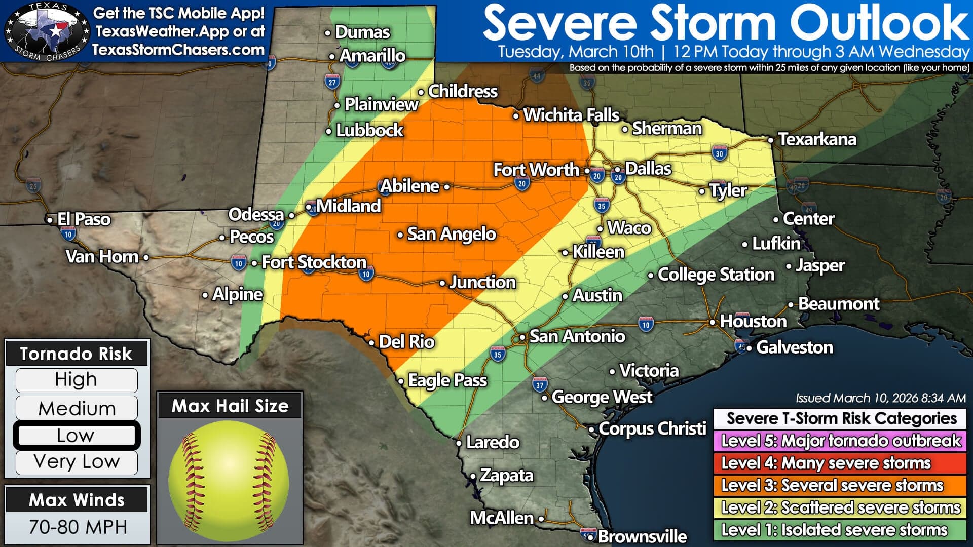
Overview and timing
A broad swath of Texas faces a multi-hazard severe weather event later today into tonight, with watches and warnings already in effect across the Dallas–Fort Worth area and other regions.
“A First Alert Weather Day is in place for both Tuesday and Wednesday due to the threat of severe weather”
CBS News reports a severe thunderstorm watch is in place until 2 a.m. for multiple counties including Collin and Dallas, and additional warnings (severe thunderstorm, flash flood, and tornado watches) cover other areas;

Texas Storm Chasers says severe thunderstorms are expected to develop across several regions of Texas later today and continue into tonight, with the Storm Prediction Center outlining a wide area of severe weather potential across Northwest Texas, Central Texas, North Texas, Texoma and Northeast Texas.
Both outlets emphasize that the main round of storms will move east through the afternoon and evening, creating a sustained threat into the night.
Hail and damaging winds
The most immediate and dramatic hazards are very large hail and destructive straight-line winds.
CBS News warns of destructive hail up to 4 inches — “roughly softball size” — and damaging wind gusts up to 80 mph in some warnings;
Texas Storm Chasers likewise notes the strongest storms could produce very large hail of three to four inches and damaging straight-line winds of 60 to 70 mph with isolated gusts approaching 80 mph,
making both large hail and extreme wind a primary concern for structures, vehicles and outdoor safety.
Tornado risk
Tornadoes are a possible but more localized threat: both outlets note watches and an isolated tornado risk ahead of the main line.
“A First Alert Weather Day is in place for both Tuesday and Wednesday due to the threat of severe weather”
CBS News says isolated strong tornadoes will be possible for any cells that form ahead of the main line and lists a specific tornado watch for Grayson and Comanche counties;
Texas Storm Chasers characterizes the tornado threat as limited in early storms but says it could increase during the late afternoon and evening, especially where discrete supercells develop in the Hill Country and Concho Valley.
Flooding danger
Heavy rain and flash flooding are also part of the threat mix, with flash flood warnings already issued in the Dallas–Fort Worth area and the possibility of several inches of rain in some locations.
CBS News lists a flash flood warning for Tarrant, Denton, Dallas and Collin counties and repeats the safety admonition “Turn around, don't drown.”
Texas Storm Chasers warns that some locations could receive a few inches of rainfall, particularly across parts of the Concho Valley, the Big Country, North Texas, Texoma, and Northeast Texas,
which could exacerbate urban and localized flooding.
Evolution and precautions
Forecasts indicate storms may begin as discrete supercells this afternoon and then organize into a damaging linear system tonight, so timing and location will determine the dominant hazards; officials and forecasters urge people to monitor warnings closely and seek shelter.
“A First Alert Weather Day is in place for both Tuesday and Wednesday due to the threat of severe weather”
Texas Storm Chasers explains storms may initially develop along a dryline and act as discrete supercells — which raises the hail and tornado threat — before the activity organizes into a line that will shift the primary hazard toward damaging wind gusts.
CBS News suggests the main line should reach parts of the western Dallas metroplex by about 10 p.m., reinforcing the need to follow watches and warnings and protect people and property.
More on USA

US Deploys Marines and Warships to Middle East as Iran Attacks Persian Gulf Shipping
15 sources compared

US Air Force KC-135 crashes in western Iraq, six airmen killed
29 sources compared

Judge James Boasberg Blocks DOJ Criminal Probe of Federal Reserve, Deems It Trump Pressure Campaign
15 sources compared
US Deploys 2,200 Marines on Three Warships Toward the Middle East Over Iran Attacks
34 sources compared