Flooding Displaces Residents in Hasakah City After Khabour River Overflows in Syria
Key Takeaways
- Hasakah residents displaced due to Khabour River flooding.
- Satellite imagery shows partial dam collapses and widespread floods across Syria.
- Satellite data show shifts in landmarks and vegetation across several provinces.
Floods in Hasakah
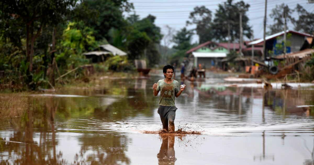
Flooding tied to heavy rains and a low-pressure system displaced residents in Hasakah city in northeastern Syria, according to Anadolu Ajansı and satellite analysis published by Al-Jazeera Net.
“Recent satellite images analyzed by the Open Sources unit at Al Jazeera Network reveal the scale of the natural disaster that struck wide swaths of interior Syria”
Anadolu Ajansı reported that on Friday “a number of residents were displaced due to the flooding of the Khabour River” in one of the city’s neighborhoods, after the river rose following “a low-pressure system accompanied by heavy rains.”

The Syrian News Channel said residents from the al-Murdiyan neighborhood moved to the shelter at Hassan Khamis School, and the channel added that “the river completely submerged the houses.”
Displaced residents quoted by Anadolu Ajansı said, “the river completely flooded our homes, and all our belongings were gone,” and they pointed to “more than 30 families at the shelter, ‘where we went out and left our belongings behind.’”
Al-Jazeera Net’s Open Sources unit connected the local flooding to a broader surge in the Khabur River, stating that satellite images showed the river’s flow “overflowed to engulf the surrounding urban areas” after reaching “about 80 cubic meters per second in the town of Tal Tamr in March.”
The same Al-Jazeera Net analysis said the flooding concentrated in neighborhoods including “Ghuiran, Al-Mirdayan, and Al-Nashwa,” and it described “widespread changes in key landmarks and vegetation cover across several provinces” coinciding with damage to water infrastructure.
Satellite-tracked infrastructure damage
Beyond Hasakah, Al-Jazeera Net’s Open Sources unit described how satellite imagery aligned with field reporting on partial collapses in water infrastructure and flooding of agricultural areas across interior Syria.
The outlet said visual analyses showed “widespread changes in key landmarks and vegetation cover across several provinces,” and it linked those changes to “serious partial collapses in water infrastructure and the flooding of extensive agricultural areas due to the heavy rainfall.”

In Hasakeh governorate, the analysis said the Khabur River surge reached “about 80 cubic meters per second” in Tal Tamr and then overflowed to engulf urban areas, while it also reported “an increase in the river’s course and a color change due to flood erosion.”
It further described “unprecedented density of vegetation along the banks due to the inundation,” using that as a satellite sign of how floodwaters reshaped the landscape.
The same satellite monitoring extended eastward into the Deir ez-Zor governorate, where Al-Jazeera Net said the disaster struck “logistical arteries” and documented “the collapse and submersion of the strategic Suwayiya border bridge.”
Al-Jazeera Net reported that the bridge “links the city of Al-Bukamal to the Iraqi border,” and it said monitoring data corroborated local reports that the bridge “went out of service,” isolating villages and “forcing authorities to use river ferries as an alternative.”
The outlet’s account also tied the flooding to the breach of the earthen embankment of the Siyaha Dam, stating that satellite images captured on “April 23, 2026” showed “a massive water flow that flooded wide areas.”
Dam breaches and food security
Al-Jazeera Net’s satellite analysis described how dam failures translated into flooding that affected agriculture and forced evacuations, with specific figures tied to the Siyaha Dam breach.
“Thousands of displaced people are still living in camps in Laos, one year after the deadly collapse of a dam, according to a report by several NGOs published on Tuesday”
The outlet said the Open Sources unit tracked “consequences for food security following the breach of the earthen embankment of the Siyaha Dam,” and it reported that satellite images captured on “April 23, 2026” showed “a massive water flow that flooded wide areas.”
It then cited an official confirmation from the commander of Civil Defense operations in Aleppo, Faisal Mohammed Ali, who stated that “the breach of the embankment in Jazraiya (Western Siyaha) led to flooding of agricultural lands estimated at about 600 hectares.”
Al-Jazeera Net said the damage extended directly to Idlib, where images showed “marked changes and flooding of parts of the town of Hamimat al-Dair and the adjacent agricultural lands,” and it added that the flooding “forcing dozens of families to evacuate.”
The outlet also named other affected villages, including “Al-Teljina, Hamimat al-Dair, and Al-Wasita al-Sharqiya,” and it described how satellite monitoring showed changes in those areas as well.
In the same report, Al-Jazeera Net contrasted the dam failures with another dam filling in northern Aleppo, saying “heavy rains brought another face to the northern countryside of Aleppo” where images showed “a small earthen dam filling in the area—the Shahba Dam.”
The outlet said the official SANA agency reported that “the dam came back to life thanks to this season’s rains,” and it quoted local visitors describing the area as “a tourist destination visited by residents from Aleppo, Azaz, and Al-Bab.”
Environmental rebound alongside damage
While Al-Jazeera Net described flood damage and infrastructure collapses, it also reported environmental changes tied to the same rainy season, including dam filling and vegetation recovery.
The outlet said “Strategic dams filling and vegetation cover revival” could be seen in satellite comparisons, with water rising at major reservoirs and “parts of beaches submerged,” and it named the Euphrates Dam and the Tishreen Dam as well as “Rastan Dam and the Hasake Dam.”
It described “a broadening of reservoir filling at dam lakes” and said the images showed “a large increase in water volume and clear lake filling.”
Al-Jazeera Net also reported “Notable activity in vegetation,” using NDVI readings to show “an unprecedented rise in chlorophyll levels” across Aleppo, Raqqa, Deir ez-Zor, Hasakeh, and Idlib.
The outlet said the NDVI results indicated improved plant health and density due to “extraordinary rainfall,” and it described a comparison to earlier seasons, stating that “at the peak of spring 2025, the images showed large green areas disappearing, while spring 2026 showed broader green coverage in the north and south.”
It further stated that “The year 2026 saw a marked rise in rainfall, approaching 300 millimeters by the end of March,” and it characterized that as “one of the best rainy seasons in the past three decades.”
The report linked the rainfall to hydrological revival, saying “the Barada, Orontes, Awej, and the Great rivers, in addition to the Beit Jen springs and many other waterways from Afrin in the north to the Golan in the south, returned to life as lifelines with unprecedented flow.”
What happens next
The sources frame the immediate aftermath as a mix of displacement, sheltering, and ongoing response efforts, while Al-Jazeera Net’s satellite findings emphasize both the scale of damage and the breadth of hydrological change.
“Syria: Displacement from a neighborhood in Hasakah city due to flooding of the Khabour River”
Anadolu Ajansı said Syria, “especially the eastern region,” is experiencing “a low-pressure system accompanied by heavy rains and strong winds,” and it described “waves of displacement from some areas and dam collapses,” adding that “as the government works to aid the affected and move them to shelters and provide assistance.”
In Hasakah city, the Syrian News Channel’s account quoted by Anadolu Ajansı described residents moving to Hassan Khamis School after the Khabour River “completely submerged the houses,” with “more than 30 families at the shelter” leaving belongings behind.
Al-Jazeera Net’s report, meanwhile, described how the Suwayiya border bridge outage “went out of service,” leaving villages isolated and “forcing authorities to use river ferries as an alternative,” which points to continuing disruption of movement and commerce.
For agriculture, Al-Jazeera Net tied the Siyaha Dam breach to flooding of “about 600 hectares” of agricultural lands and said the flooding in Idlib was “forcing dozens of families to evacuate,” indicating that displacement and food-security impacts were still unfolding.
At the same time, the report said strategic reservoirs including the Euphrates Dam, Tishreen Dam, Rastan Dam, and Hasake Dam showed “a large increase in water volume and clear lake filling,” and it reported “unprecedented flow” in rivers and springs from Afrin to the Golan.
The combined picture in the sources is therefore not only of disaster response but also of a rapidly changing environment, with vegetation and water systems rebounding even as some communities face evacuation and infrastructure failures.
More on Syria

Iraq and Syria Dismantle International Drug Network, Seize 200 Kilograms in Homs and Deir ez-Zor
14 sources compared
Russia Discusses Possible Restructuring of Tartus and Khmeimim Bases With Damascus
11 sources compared

Marco Rubio Ends Tom Barrack’s US Special Envoy Mandate for Syria
11 sources compared

Ahmed al-Sharaa Visits Deir Ezzor After Euphrates Floods Displace Thousands
18 sources compared