Full story
Bertha Hits Louisiana
Tropical Storm Bertha made landfall along the southeastern Louisiana coast on Wednesday afternoon, with the National Hurricane Center saying the center crossed the coast near the Biloxi Wildlife Management Area in St. Bernard Parish around 3 p.m. EDT.
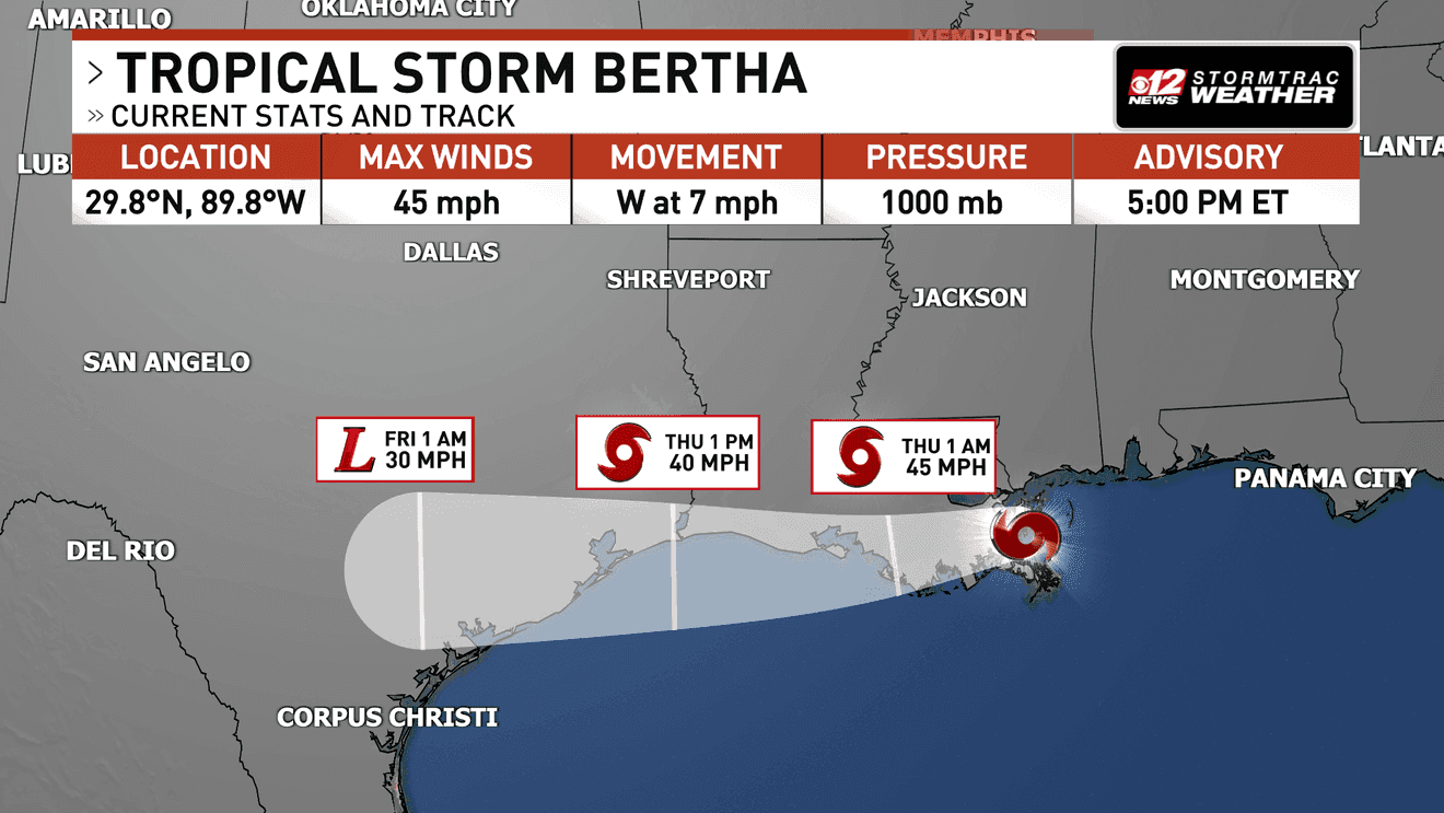
At landfall, Bertha had maximum sustained winds of 45 mph with higher gusts, and it was about 40 miles east of New Orleans and 45 miles southwest of Biloxi, Mississippi while moving west-northwest at 7 mph with a minimum central pressure of 1,000 millibars.

The storm’s center was forecast to move near or along the Louisiana and upper Texas coasts through Thursday before moving farther inland over Texas on Friday, while a tropical storm warning remained in effect from the Alabama-Florida state line to Morgan City, Louisiana.
The National Hurricane Center said Bertha could bring 1 to 4 inches of rain, with isolated totals reaching 6 inches, from Northwest Florida to southern Texas through Friday, and it also warned that storm surge of 1 to 3 feet above normally dry ground was possible from the Alabama-Florida line to Port Bolivar, Texas, as well as around Lake Pontchartrain.
In Spanish-language coverage, El Centro Nacional de Huracanes reported maximum sustained winds of 72 kilómetros por hora as Bertha reached St. Bernard, and said authorities maintained vigilance for heavy rains and possible flooding.
Warnings, Heat, and Rain
The National Weather Service said much of southern Louisiana on Wednesday was under both tropical storm and extreme heat warnings, described as a rare combination, and it was the first time the region had been under both warnings simultaneously in at least two decades based on records dating back to 2005.
Louisiana Gov. Jeff Landry called the forecast “encouraging” while warning residents to be prepared for some flooding and the hurricane season in general, and forecasters said flooding and coastal inundation would likely be Bertha’s biggest hazards.

The National Hurricane Center said tropical storm conditions were expected to expand westward along parts of the northern Gulf Coast from the Florida Panhandle to southeastern Louisiana, including the New Orleans metropolitan area, through Wednesday night.
The NHC also warned that “isolated areas of flash flooding” were possible through early Friday along the Gulf Coast, from western Florida into southern Texas, and it said swells generated by Bertha would continue spreading westward along the northern Gulf Coast.
In coverage focused on the broader U.S. impacts, Newsradio 1040 said flood watches were in effect for six states—Maryland, Virginia, North Carolina, Tennessee, Georgia, and Alabama—because a stalled cold front drew moisture from the Gulf of Mexico and Bertha contributed heavy rainfall.
What Comes Next
As Bertha weakened after landfall, forecasters expected it to remain a tropical storm through late Thursday, with strong wind shear pushing much of the storm’s thunderstorm activity away from its center and contributing to gradual weakening.
The National Hurricane Center said the storm’s center was forecast to move near or along the Louisiana and upper Texas coasts through Thursday before moving farther inland over Texas on Friday, and it warned that Bertha could still produce rainfall and dangerous marine conditions across parts of Northwest Florida.
In the Mid-Atlantic and Carolinas, NOAA issued a Level 3 flood threat for parts of the area, while FOX Weather warned that repeated rounds of heavy rain were expected through at least Friday (July 24), with Eastern North Carolina likely to experience the highest rain totals.
Newsradio 1040 reported that the threat of flash flooding extended to parts of Virginia and the Delmarva Peninsula, with a Level 2 flood risk covering much of the Mid-Atlantic and Appalachian regions, and it said the flood threat was expected to shift southward by the end of the week.
Meanwhile, South Carolina Public Radio said forecasters expected Bertha to track along the northern Gulf Coast for several days and that it was expected to bring up to four feet of storm surge and sustained winds as high as 50 miles per hour, even as it was not expected to strengthen into a hurricane.