National Weather Service Warns Tornadoes, Large Hail Across Missouri, Iowa, Illinois, Minnesota, Wisconsin
Key Takeaways
- Multi-state outbreak hits Minnesota, Wisconsin, Illinois, Missouri, and Iowa.
- Hazards include tornadoes, large hail, damaging winds, and flash flooding.
- Tornado watches and warnings blanket a broad Midwest region.
Midwest tornado watch surge
A new round of severe weather threatened the U.S. Midwest on Friday, with the National Weather Service warning that storms could develop from north-west Oklahoma through western Missouri on Friday afternoon and evening.
“The threat of strong tornadoes, large hail, damaging winds and flash flooding is returning to the central U”
The National Weather Service said the system may produce large hail, with stones potentially reaching the size of a baseball, and warned that hail can fall at speeds of up to 107mph while advising residents to stay indoors and away from windows.

According to CNN, around 26 million people were under tornado watches stretching from Wisconsin to Oklahoma, and the outlet also reported that a rare “particularly dangerous situation” alert had been issued for one tornado in Illinois and two in Wisconsin.
Newsweek described “numerous tornado warnings” issued simultaneously across five states on Friday afternoon, putting around 142,000 people in the direct path of dangerous and potentially life-threatening tornadoes.
As of Friday afternoon, just before 5 p.m. ET, National Weather Service meteorologists issued urgent tornado warnings for Missouri, Iowa, Illinois, Minnesota, and Wisconsin.
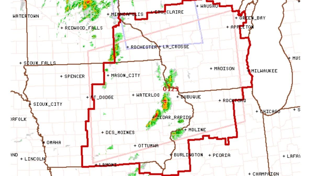
The Watchers reported that the Storm Prediction Center issued Tornado Watch #129 at 17:40 UTC (12:40 CDT) on April 17, 2026, valid until 20:00 CDT, covering central and eastern Iowa, northern and west-central Illinois, southeast Minnesota, far northeast Missouri, and central and southern Wisconsin.
CBS News added that the threat of strong tornadoes, large hail, damaging winds and flash flooding was returning Friday evening into the start of the weekend, with the Upper Mississippi Valley spanning parts of Illinois, Iowa, Minnesota, Wisconsin described as having “the best chance for strong tornadoes.”
Warnings, speeds, and hail
As the severe weather threat unfolded, Newsweek reported that a “particularly dangerous situation” alert developed in northwestern Illinois as a large, confirmed tornado remained on the ground Friday afternoon in Jo Daviess and Stephenson counties.
The tornado was confirmed by weather spotters and was moving east around 25 mph, prompting urgent life-safety messaging from the NWS office in Quad Cities.
Newsweek quoted the NWS office: “You are in a life-threatening situation,” and warned that “Flying debris may be deadly to those caught without shelter.”
The warning also said “Mobile homes will be destroyed,” and that “complete destruction is possible,” while urging residents to “TAKE COVER NOW! Move to a basement or an interior room on the lowest floor of a sturdy building.”
Newsweek further listed communities including McConnell, Freeport, Cedarville, Orangeville, and Dakota, with warnings emphasizing that heavy rainfall could obscure visibility of the tornado.
The Watchers’ meteorological analysis described a “highly unstable environment ahead of an advancing cold front,” with tornadoes, large hail, and strong wind gusts as primary hazards, and it said large hail could reach diameters “up to 9 cm (3.5 inches)” while damaging wind gusts could reach “up to 113 km/h (70 mph).”
It also stated that supercells developing ahead of the front would be capable of producing “all severe hazards, including very large hail and strong to intense tornadoes,” and that thunderstorm tops may reach around “15 200 m (50 000 feet).”
CBS News similarly framed the returning threat, saying the Upper Mississippi Valley would have “the best chance for strong tornadoes,” while other parts of the central U.S. and Midwest would have “the best chance for very large hail.”
Aftermath and emergency response
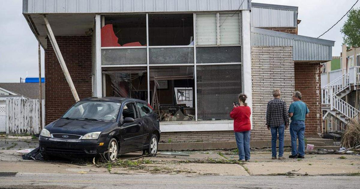
Beyond the forecasts, CBS News described communities still cleaning up from tornadoes that struck earlier in the week, including a western New York community south of Buffalo that was “picking up the pieces” Thursday after a small tornado caused “tremendous damage.”
“Numerous tornado warnings have been issued simultaneously across five states on Friday afternoon as a series of destructive storms tears through the Central and Midwestern United States, putting around 142,000 people in the direct path of dangerous and potentially life-threatening tornadoes”
CBS News also reported that in Clinton, Missouri, two twisters struck Wednesday night, sending trees crashing onto Andrew Donaldson's roof and garage, and Donaldson said, “I've never seen anything like that,” adding, “I don't ever want to see it again.”
The same CBS report said Michigan was dealing with record flooding, and it quoted Gov. Gretchen Whitmer declaring a state of emergency for 33 counties, saying, “We are in crisis mode now,” and “Recovery mode will take additional work.”
It added that the Muskegon River in the western part of the state reached new record highs, and that in northern Michigan water was “dangerously close to breaching a dam in Cheboygan,” with officials “monitoring high water levels everywhere.”
In Milwaukee, Wisconsin, roads were still flooded Thursday after a torrential rainstorm slammed the area Wednesday night, and CBS News reported that a 41-year-old man was killed by a suspected lightning strike in the state.
The News International’s Asian report similarly described storm damage already reported across several states, including flash flooding in Milwaukee that left drivers stranded and roads closed, and it said a man in Waukesha died after being struck by lightning.
It also said the severe conditions followed a week of extreme weather in the region, tying the latest tornado risk to ongoing impacts from earlier storms.
Data gaps and balloon changes
A separate but related thread in the reporting focused on whether changes to weather balloon launches affected tornado forecasting, after a tornado outbreak near Kansas City, Kansas, on Monday night came as a surprise.
NBC News said at least five tornadoes developed in areas southwest of the city, with at least three injuries reported, and it noted that in its Monday afternoon outlook the National Weather Service’s Storm Prediction Center did not anticipate a tornado threat for the Kansas City area.

NBC News reported that the disconnect prompted concerns among some outside meteorologists that “ongoing changes to staffing and weather balloon releases” might be leaving forecasters in the dark about threats.
The article said many forecasting offices in the Great Plains did not launch weather balloons at 7 a.m. Monday, and instead released the balloons at noon, a change several meteorologists thought was made because of staffing issues.
“We are missing data at the normal times,” said Chris Vagasky, a meteorologist and research manager at the Wisconsin Environmental Mesonet, and he added that the staggered balloon launches left a “big area over the southern Plains in the central United States without that weather balloon data, which might have caused the models to not forecast the day’s activity as well as it could have.”
NBC News also reported that the strongest tornado in the Kansas City area Monday was rated EF2 on the enhanced Fujita scale, with wind speeds reaching about 125 mph according to preliminary damage reports.
It said forecast models did not show the threat of tornadoes until the risk was on the doorstep, and that the weather service issued watches at about 6:35 p.m., about half an hour before the first tornado.
In response, NBC News quoted Erica Grow Cei, a spokesperson for the weather service, saying, “NOAA’s weather model performance has not been impacted by any changes to the schedule of our twice-daily radiosonde (weather balloon) launches,” and “NOAA’s weather model performance shows no evidence of degradation.”
Staffing, sirens, and next steps
NBC News connected the balloon schedule scrutiny to broader staffing changes, describing that for decades the weather service released weather balloons at a clockworklike cadence at more than 100 sites across the country, as well as over the Pacific and the Caribbean.
“The Storm Prediction Center issued a Tornado Watch for a multi-state region of the Upper Midwest at 17:40 UTC (12:40 CDT) on April 17, 2026, citing a highly unstable environment ahead of an advancing cold front”
The article said the Trump administration cut the agency deeply last year through buyouts and by firing probationary workers, leaving some forecasting offices short-staffed and scrambling to fill key roles.
NBC News reported that as a result, the agency halted balloon launches at some locations and delayed them elsewhere, and it said Alan Gerard, a meteorologist who retired last year as the director of analysis and understanding at NOAA's National Severe Storms Laboratory, argued the schedule change was tied to staffing issues.
Gerard said, “They’ve been deferring them to the day shift — midday — for when they have more staff,” and he added, “It’s like we’re conducting a real-time experiment without any way to evaluate what the impacts of it are.”
NBC News also described how some forecasting models are timed to run in the morning just after 7 a.m. local time, and that on Monday balloon data from the central Plains did not come in until after those morning models had run, so it was not factored in.
The reporting emphasized that notice ahead of a possible tornado is critical to give people time to take shelter, explaining that ideally a watch is issued several hours before an event and then a warning goes out when a tornado is imminent.
It also stated that research suggests tornado warnings typically go out about 15 minutes in advance, and it noted that some local governments sound tornado sirens when forecasters issue tornado warnings.
The article ended by pointing to a similar, much-scrutinized event in Michigan last month, when a tornado watch was not issued for southern Michigan and four people died, while weather service offices did issue warnings when tornadoes were imminent.
More on Technology and Science

Blue Origin Reuses New Glenn Booster for First Time on NG-3 From Cape Canaveral
12 sources compared

Austria Police Find Rat Poison in HiPP Baby Food Jar, Triggering Recall at SPAR
12 sources compared

Trump Signs Executive Order To Fast-Track Psychedelic Drug Research, Including Ibogaine
52 sources compared

Sam Altman’s World Expands Proof-Of-Human Verification With Tinder, Zoom, and Docusign
15 sources compared