
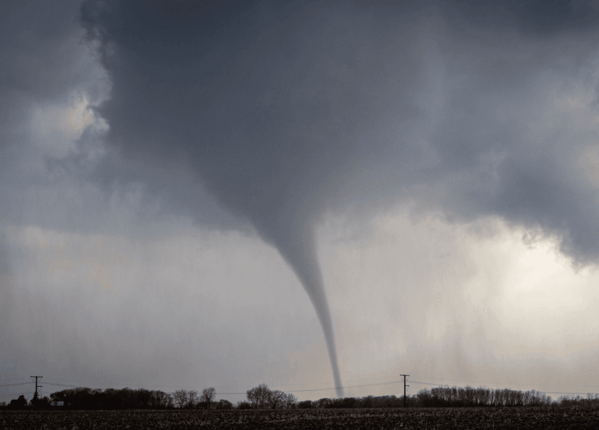
Tornadoes Touch Down Near Rochester, Marion, Plainview, And Stewartville In Southeast Minnesota
Key Takeaways
- Multiple tornadoes reported in the Rochester area.
- Alerts issued for Marion and Stewartville; near Rochester International Airport.
- Baseball-sized hail accompanied the storms.
Tornadoes near Rochester
Severe thunderstorms produced tornadoes Friday afternoon in southeast Minnesota, with the National Weather Service reporting multiple sightings of tornadoes south and east of Rochester between 2 and 3 p.m., including a report from the Rochester Airport tower.
The weather service reported a damaging tornado in the Marion area southeast of Rochester just before 3 p.m. and another tornado near Plainview, while some homes and businesses in southeastern Rochester saw severe damages.

Videos and pictures described homes with walls and siding ripped off, and at least one home missing a roof, as trees were blown down and blocked roads.
Much of the damage occurred along Marion Road, which cuts through the southeastern part of the city, and a large swath of the road was closed to traffic Friday afternoon.
Damage to homes and trees was also seen in nearby Stewartville, just south of Rochester, and residents and volunteers began cleanup efforts in a storm-damaged neighborhood near 2204 Marv’s Lane following a tornado on April 17.
The storm also produced hail Friday afternoon across southern and eastern Minnesota, and the Minnesota Department of Transportation captured an apparent tornadic thunderstorm on traffic cameras as it moved south and east of Rochester on Friday, April 17, 2026.
The Weather Channel said cameras were rolling as a tornado spun up and struck areas near Rochester, Minnesota, live on Friday afternoon, describing it as “the first confirmed tornado in a large-scale threat.”
Warnings, roads, and power
As tornado reports spread across the Rochester area, multiple outlets described both the scope of the weather and the immediate steps taken by authorities and utilities.
KAALTV said severe weather tore through SE Minnesota and northern Iowa on Friday with multiple tornadoes touching down throughout the area, and 5 EYEWITNESS NEWS reported that rapidly changing weather produced multiple tornadoes Friday afternoon in southeast Minnesota, according to eyewitness video and reports submitted to the Storm Prediction Center (SPC).

The KSTP report listed tornado reports from around the Rochester area, including in Hayfield, Marion, Sargeant, Stewartville and Elgin, and said at least one was confirmed to have touched down.
KARE11 described “2 potential tornadoes” spotted near Rochester airport, while Hindustan Times said the National Weather Service issued a Tornado Warning for portions of southeastern Minnesota and quoted the alert: “At 1:52 PM CDT, weather spotters confirmed a tornado located 7 miles east of Hayfield (or 12 miles southeast of Dodge Center).”
The Hindustan Times alert also warned, “Flying debris will be dangerous to those caught without shelter,” and said “Damage to roofs, windows, and vehicles will occur. Tree damage is likely.”
In Rochester, Rochester Public Schools posted updates stating tornado sirens were sounding and that all students had been moved to designated safety areas, then later wrote, “Students are in their designated shelter spaces.”
Meanwhile, the MPR News account said Minnesota utilities reported more than a thousand homes and businesses without power as of Friday evening, including more than 3,200 People’s Energy Cooperative customers in the Stewartville and Marion areas south and east of Rochester, and also in the Plainview area.
Injuries and emergency response
The storm’s impacts included injuries tied to tornado activity and a rapid response by emergency services, utilities, and schools.
MPR News reported that a driver of a semi-truck was injured when a tornado caused his truck to flip, and it said the driver survived with non-serious injuries and was taken to a nearby hospital.
KROC-AM News added more detail, saying a 55-year-old truck driver from Bloomington suffered non-life-threatening injuries when in approaching tornado caused his semi-truck to flip onto its side along westbound I-90 near the Rochester Airport around 2:45 PM.
The KROC-AM report also said deputies and other emergency responders were securing the area and going door to door to assess the damage, while requesting that individuals who had experienced property damage not call law enforcement at that time to keep emergency lines open for urgent needs.
It described a temporary shelter established for anyone in need at the Autumn Ridge Church at 3611 Salem Road Southwest in Rochester, advising anyone seeking shelter to bring necessary medications, identification, and essential personal items.
MPR News also described how Rochester Public Schools held students at their designated safety spots for a time, and the district issued an update shortly before 3 p.m. stating that buses at elementary schools will begin loading and bringing students home, with middle and high school students transported after and expecting about an hour delay.
Hindustan Times similarly described the district’s Facebook updates, including that students would remain in designated shelter spaces until an all-clear is issued by the National Weather Service, and that dismissal would likely be delayed.
How outlets framed the same day
While the underlying event was consistent—tornadoes touching down around Rochester and damage across southeastern Minnesota—outlets emphasized different elements, from official timing to viewer footage and live broadcast framing.
MPR News anchored its account in National Weather Service reporting, stating tornado sightings were reported “between 2 and 3 p.m.” and describing a damaging tornado in the Marion area just before 3 p.m., then tying damage to specific corridors like Marion Road.
5 EYEWITNESS NEWS, by contrast, leaned on eyewitness video and Storm Prediction Center submissions, saying reports came in from around the Rochester area including Hayfield, Marion, Sargeant, Stewartville and Elgin, and that at least one was confirmed to have touched down.
KSTP also described a traffic management camera capturing a “ropy tornado form” near the Rochester International Airport, while KAALTV presented a gallery of viewer-submitted photos, listing locations such as Stewartville, MN and Rochester, MN.
KARE11’s headline focused on the airport area by reporting “2 potential tornadoes spotted near Rochester airport,” and Hindustan Times foregrounded the National Weather Service warning language, quoting “At 1:52 PM CDT” and listing forecast locations such as Rochester and Stewartville around 2:05 PM CDT.
The Weather Channel framed the event through its own live coverage, saying “Cameras were rolling as a tornado spun up and struck areas near Rochester, Minnesota, live on The Weather Channel,” and describing the twister as “the first confirmed tornado in a large-scale threat.”
Even the power-outage numbers showed divergence in how outlets reported the same disruption: MPR News said “more than 3,200 People’s Energy Cooperative customers,” while Y105FM said “approximately 2500 of its customers were without power” as of 5 PM.
Aftermath and continuing risk
After the tornado activity, the sources described cleanup efforts, ongoing road and utility impacts, and the continued need for public caution.
“Opens in a new window Opens an external website Opens an external website in a new window <”
MPR News reported that residents and volunteers began cleanup efforts in a storm-damaged neighborhood near 2204 Marv’s Lane following a tornado on April 17, describing how the storm scattered debris across yards and damaged homes as community members worked to clear the area.
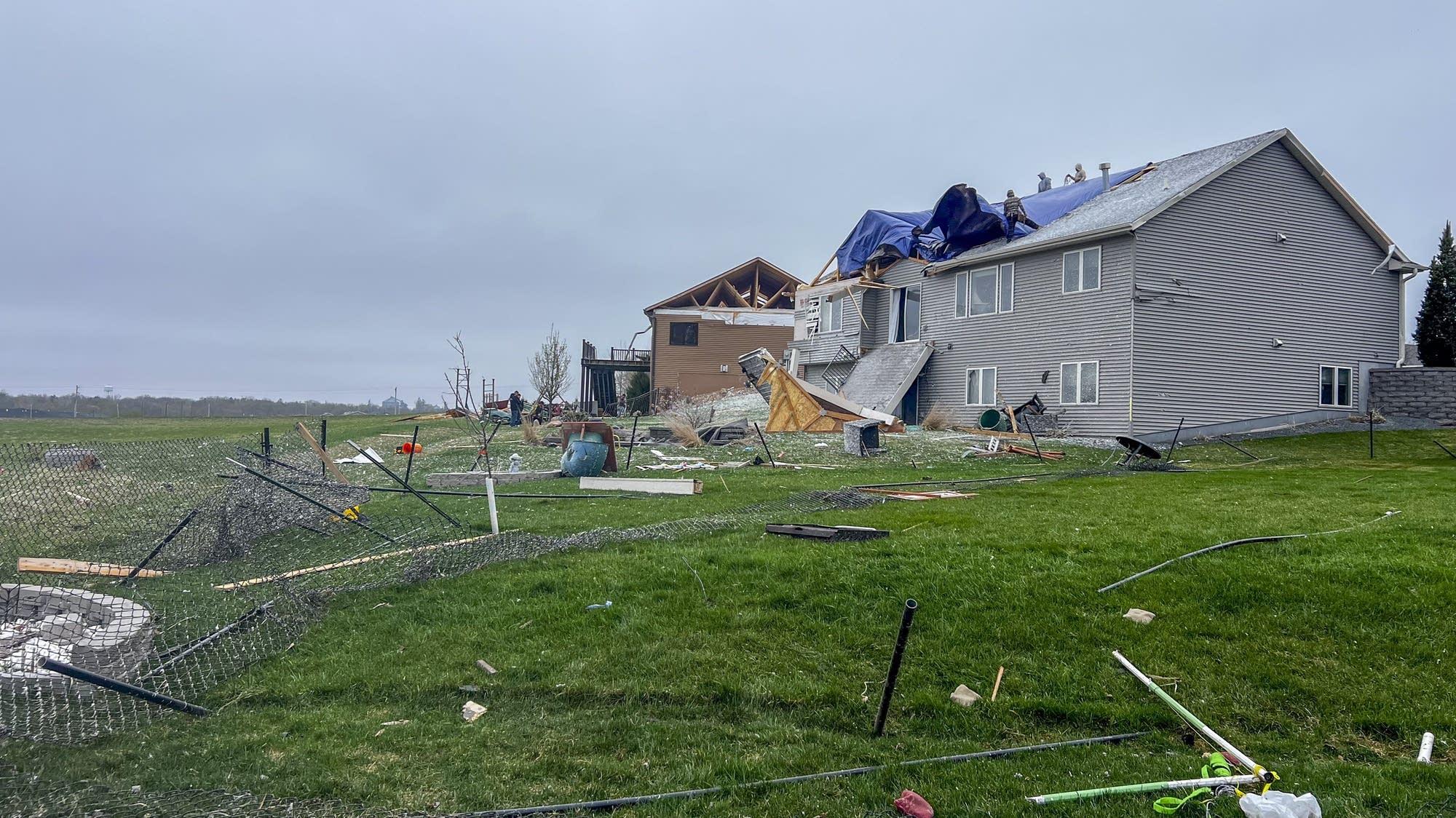
It also said trees were blown down and blocking roads, and that a large swath of Marion Road was closed to traffic Friday afternoon, reflecting how damage affected movement even after the storm passed.
The KROC-AM report said deputies and other emergency responders were going door to door to assess the damage, and it described an avoidance request for northeast Stewartville and areas along Marion Road Southeast between 50th Avenue Southeast and 30th Street Southeast due to storm damage.
It also said utility crews were busy responding to power outages affecting several hundred homes in the same areas, and it provided the People’s Cooperative Power figure of approximately 2500 customers without power as of 5 PM.
Hindustan Times described the school response as continuing until the National Weather Service issued an all-clear, quoting that students would remain in designated shelter spaces until the warning expired and that the district would send an all-clear message when it received it.
The Weather Channel’s live framing suggested the event was part of a broader severe weather threat, saying it was “part of a possible severe weather outbreak in the Midwest and Plains Friday afternoon and evening.”
More on Technology and Science

Typhoon Bavi Kills At Least 15 in Philippines as It Threatens Taiwan and Japan
19 sources compared

Wildfire Kills At Least 12 Near Los Gallardos, Leaving 23 Missing In Andalusia
41 sources compared

OpenAI Sunsets ChatGPT Atlas Browser, Pivots to ChatGPT Desktop App With ChatGPT Work
13 sources compared

FTC And Five States Reach 10-Year Right-To-Repair Settlement With Deere & Company
10 sources compared