Full story
UN backs new map
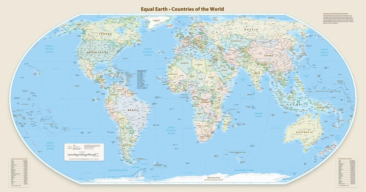
The United Nations General Assembly voted to endorse a new world map that represents Africa more accurately in its larger size, with a Friday resolution sponsored by Togo and backed by members of the African Union.
“passed with 164 member states voting in favor”
The vote passed with 164 member states voting in favor, while only the U.S. voted against and six other countries — Serbia, Estonia, Georgia, Lithuania, Moldova and Ukraine — abstained.

The resolution encourages governments and institutions to replace the traditional Mercator map with the Equal Earth projection, and it says the Mercator projection shows Greenland and Africa as appearing to be about the same size whereas in the Equal Earth projection Africa is 14 times larger than Greenland.
The UN said the resolution does not ban the Mercator projection or impose a replacement, but only encourages the use of the Equal Earth projection, and it quoted Togo’s Foreign Minister Robert Dussey saying, “Maps shape our understanding of the world.”
Debate over neutrality
Before the vote, Togo’s Foreign Minister Robert Dussey told Reuters that “a fair world begins with a fair map,” and he also argued at an UN briefing that “A map is never neutral. It shapes perceptions and influences how the place of peoples and continents is understood in the world.”
The BBC reported that the Mercator projection, in common use since the 16th century, has been criticized for showing Africa with a size similar to Greenland’s despite being 14 times larger, and it said the distortion is tied to the impossibility of accurately representing a globe on a two-dimensional chart.
The U.S. representative to the UN, Linda Thomas-Greenfield, argued that the resolution mocked the work and purpose of the UN General Assembly, saying, “this body is debating 16th-century cartography projects and its role in promoting reparations and ‘cognitive justice,’”
The BBC also said Lerato Mogoatlhe of Africa No Filter described the misrepresentation as “not just a cartographic error, but a narrative problem,” and it added that the campaign aims to curb “longest-lasting misinformation and disinformation in the world” about Africa.
What changes next
The resolution is described as non-binding, but the BBC said it will lead to changes in the maps used by institutions around the world, and it said the Mercator map was designed in 1569 by Flemish cartographer Gerardus Mercator to help European explorers navigate the world.
““you could fit the United States, China, India, Japan, Mexico, and much of Europe inside Africa”
The BBC reported that in February, the 54 AU member states adopted Equal Earth and said it “represents more accurately the size of all continents, particularly Africa,” and it noted that the #CorrectTheMap campaign stated, “you could fit the United States, China, India, Japan, Mexico, and much of Europe inside Africa and there would still be land left over.”
France’s Foreign Minister Jean-Noël Barrot said on X that “Changing the map obviously does not change the world. But correcting a representation that distorts it is already an act of truth,” and the BBC said he stated the chancery would stop using the Mercator map.
The ABC News report said the vote encourages governments and institutions to replace traditional Mercator maps with Equal Earth, and it quoted Africa No Filter’s campaign message that it “We want to see accurate maps in schools, textbooks, newsrooms, businesses and on the digital platforms billions of people use every day.”