Full story
UN backs Equal Earth
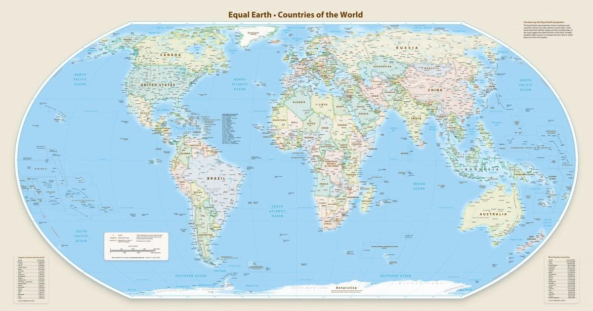
The United Nations General Assembly approved a resolution promoted by several African countries to adopt a new world map that reflects the real size of the African continent and reduces the dimensions of North America and Europe, with the vote backed by 164 countries and the United States voting against while six other states abstained.
“The United States voted against and six other states abstained.”
The initiative, led by Togo with the support of other African nations, urges member states to adopt the new map instead of the traditional Mercator projection designed for sea navigation by Flemish cartographer Gerardus Mercator in 1569.

The Mercator projection has been criticized because it shows Africa with a size similar to Greenland despite Africa being 14 times larger, and the resolution promotes the Equal Earth projection as a more accurate representation of the sizes of continental masses.
France’s foreign minister Jean-Noël Barrot announced that France will abandon the Mercator projection in favor of representations that more accurately show the surface area of countries, and he said “distortions eventually take root in perceptions” and “the time has come to correct them.”
Voices hail, US objects
Togo’s Foreign Minister Robert Dussey told the Reuters news agency ahead of Friday’s vote that “A fair world begins with a fair map,” as the UN general assembly adopted the “Correct the Map” resolution sponsored by African states to right a centuries-old wrong.
The resolution was backed by a vote of 164-1 with six abstentions, and Al Jazeera reported that the United States said the measure promoted an “ideological agenda” and was a distraction from the “genuine problems of international peace, prosperity or good relations”.
Moky Makura, executive director of Africa No Filter involved in the “Correct the World” map campaign, hailed the vote by saying “now the real work begins,” and she added that “We want to see accurate maps in schools, textbooks, newsrooms, businesses and on the digital platforms billions of people use every day,”.
France co-sponsored the resolution and Barrot said “The United States, Russia and China take on a disproportionate visual prominence compared to Africa, Latin America or southeast Asia,” while adding that “distortions eventually take root in perceptions” and “the time has come to correct them.”
What changes next
The resolution is not legally binding and, as the Togolese ministry said in a statement, it “in no way challenges the use of the Mercator projection for maritime and aerial navigation, for which it remains fully suited,” while it promotes Equal Earth for more accurate portrayal of the size of the continents.
“it “in no way challenges the use of the Mercator projection for maritime and aerial navigation”
Togo told Reuters that it hopes to change its school geography materials by the end of the year, and it said it will press other governments, schools, international organisations and technology companies to move away from the Mercator map in favour of the Equal Earth one.
Al Jazeera reported that the discussion about next steps would need to include companies operating mapping, GPS and other location-based technologies, and it said Dussey linked the campaign to wider African efforts to confront colonial-era legacies while saying it was not an attack on Europe or any other civilisation.
In France’s case, the foreign ministry said it will abandon the Mercator projection in favour of map representations tailored to specific uses, more faithful to actual surface areas, and in line with the recommendations of cartographers and scientists, as Barrot framed the shift as correcting distortions that “take root in perceptions.”