Gaza Genocide · updated 1h ago · 2 min read
Google Maps Shows Gaza’s Rubble As UNRWA Says 200,000 Buildings Damaged
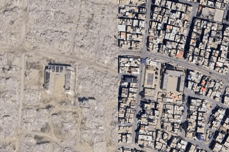
Updated Google Maps imagery shows extensive destruction across Gaza, with entire neighborhoods reduced to rubble. Rafah and southern Gaza highlighted by new images revealing large-scale housing and infrastructure damage.
10 outlets told this the same way.
2 of 4 outlets skipped it: google markers exist though buildings may not.
Al Jazeera was read line by line by the Watchdog: 4.5. See the score →
10outlets compared
Satellite view of ruins
Google Maps updated satellite imagery shows the scale of destruction across the besieged Gaza Strip nearly three years into Israel’s war, with neighbourhood after neighbourhood reduced to rubble and little left but faint outlines of main roads. UNOSAT found that the number of destroyed structures across Gaza increased by 9 percent since a “ceasefire” took effect nearly a year ago, and UNRWA said about 82 percent of structures, roughly 200,000 buildings, have been damaged with about two-thirds destroyed.
Al Jazeera said the images can be compared from Rafah in the south to North Gaza, with Rafah images captured this year and northern Gaza images dating from 2025 and 2024. Al Jazeera reported that Rafah’s Tal as-Sultan became a major refuge, but about one million people were forced to flee the area after Israeli military operations began there in May 2024, and most moved toward Khan Younis and Deir el-Balah as UNRWA shelters in Rafah were emptied.

Residents search for homes
Gazans tracked destroyed houses through Google Earth and Google Maps, and the Al Jazeera Network’s Open Sources unit published a report titled “What does Gaza look like on Google and Apple Maps?” highlighting the latest updates of Google Earth images for 2026.
Tamer al-Nuwaizi shared two photos with the caption, “The first photo shows my house and my neighborhood on the map. The second was taken after the area turned into ruins... the map shows what existed once, not what happened afterward.”

Abu Saleh, a dentist from Gaza, said, “I opened Google Maps after hearing about the image updates. I wanted to see Gaza, my neighborhood, my street, the house I grew up in. I searched for a long time and found nothing.”
A Gaza survivor wrote, “For me as a Palestinian who survived this ongoing genocide, when I look at the ruins of homes on Google Maps, I do not just see the remains of buildings that appear from afar as eroded walls.”
What the damage means
UNOSAT estimated that more than 80% of Gaza’s structures were damaged or destroyed, and the World Health Organization reported that at least 94% of hospitals were affected. The UN warned that many structures still standing are unstable, and the sources described how debris removal could take several years while also noting that under the rubble there would still be thousands of bodies and unexploded munitions.
“The World Health Organization reported that at least 94% of hospitals were affected.”
Francesca Albanese warned, “Gaza’s rubble contains human remains and physical evidence relevant to investigating alleged international crimes,” and she added that debris crushing and removal operations should not impede recovery of human remains or destroy potential evidence. The sources also said Israel rejects accusations of war crimes and maintains that its operations targeted Hamas and its military infrastructure, while the Palestinian organization is accused of using hospitals, schools, and residential areas for military purposes.