Technology and Science24 August, 20263 min read
NHC Monitors Invest 96L and Invest 95L as El Niño Strengthens, Dolly Next
This article is an automated aggregation of coverage from news outlets. Our editorials offer in-depth analysis curated by the NewsCord team.
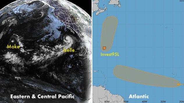
Invest 96L and Invest 95L in the Atlantic may become Tropical Storm Dolly this week. Two Atlantic systems show increasing odds to develop into Dolly, with one near Bermuda.
11 outlets told this the same way.
Outlets did split on U.S. Supreme Court Weighs Boulder Climate Lawsuit Against Suncor And ExxonMobil →
Atlantic invests and El Niño
The National Hurricane Center is monitoring two areas for potential tropical development in the Atlantic basin as a strengthening El Niño continues to impede a quiet start to the hurricane season, with plumes of dust from North Africa's Saharan Desert also in play. One system has been designated Invest 96L after a strong tropical wave moved off the coast of Africa, and FOX Weather reports it is being given medium odds of developing over the next seven days over a broad area of open ocean between Cabo Verde and the Caribbean. FOX Weather Hurricane Specialist Bryan Norcross said, "Many of the computer simulations that show it surviving its encounter with the dust and hostile upper winds predict it will turn into a hurricane as it heads north of the Caribbean," while adding, "That wouldn't be until next week, so it's nothing to think too hard about at this point."
Meanwhile, a broad area of low pressure a few hundred miles east-southeast of Bermuda has been tagged as Invest 95L, which WPTV says has a 50% chance of development over the next 48 hours and a 50% chance over the next seven days. If Invest 96L or Invest 95L becomes a tropical depression, the next name on the list is Dolly, and FOX Weather says regardless of development the system could bring rain to Newfoundland, Canada sometime Tuesday.

Hawaii’s Moke and rainfall
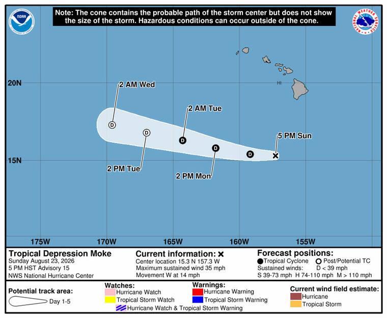
In the Central Pacific, Tropical Storm Moke weakened to a tropical depression but still posed a rainfall threat for Hawaii island, with the Honolulu Star-Advertiser citing the Central Pacific Hurricane Center for heavy rainfall and gusty winds. At about 5 p.m., Moke was located about 335 miles south-southwest of Hilo and traveling west near 14 mph, with maximum sustained winds of 35 mph and higher gusts, and the forecast called for Moke to pass south and southwest of Hawaii island tonight then well south of the smaller main Hawaiian Islands tonight and Monday. The Honolulu Star-Advertiser forecast said Moke is expected to produce rainfall totals of 3 to 6 inches across Hawaii island through Monday, and it also forecast up to 1 or 2 inches of rain across western Maui and the rest of the islands.
The National Weather Service wind advisory language quoted by the Star-Advertiser warned, "Winds this strong can tear off shingles, knock down tree branches, blow away tents and awnings and make it difficult to steer, especially for drivers of high profile vehicles," and it also said the flood watch remains in effect for Hawaii island through Monday afternoon. Newsweek’s coverage placed Moke in the wider context of a busy Pacific basin, noting that Hawaii was still recovering from Hurricane Lala and contending with impacts from Moke while the NHC monitored six tropical threats.
Forecast churn and named storms
Across the Atlantic, local and national outlets described shifting odds for whether Invest 95L and Invest 96L could become the next named storm, with the Orlando Sentinel saying the NHC increased odds for Invest 96L while dropping chances on Invest 95L. As of the NHC’s 8 a.m. tropical advisory, the Orlando Sentinel reported Invest 96L had a 70% chance to develop in the next two to seven days, and it quoted NHC forecasters saying, "Environmental conditions appear conducive for gradual development, and this system is likely to become a tropicaldepression during the next day or two." The same Orlando Sentinel account said the other system, Invest 95L, had a 40% chance of developing in the next two to seven days after the NHC dropped its forecast, and it added that either system could become Tropical Storm Dolly with Tropical Storm Edouard potentially up next.
“That wave is moving into a pocket of low wind shear and high moisture.”
In a separate local account, the Palm Beach Post said the tropical wave west of Africa—now designated as Invest 96L—was showing the highest chance for development this week, and it quoted AccuWeather Lead Hurricane Expert Alex DaSilva: "That wave is moving into a pocket of low wind shear and high moisture." The Palm Beach Post also tied the forecast to the calendar, stating that the next named storms of the season will be Dolly and Edouard and that mid-August through mid-October is the busiest period of the Atlantic hurricane season.