Technology and Science02 September, 20263 min read
Tropical Storm Marie Forms Near Manzanillo, Bringing High Waves and Rip Currents to Southern California
This article is an automated aggregation of coverage from news outlets. Our editorials offer in-depth analysis curated by the NewsCord team.
Marie formed off Baja California, strengthening toward hurricane status over the Labor Day weekend. Southern California beaches faced dangerous surf, strong currents, and coastal flooding over Labor Day.
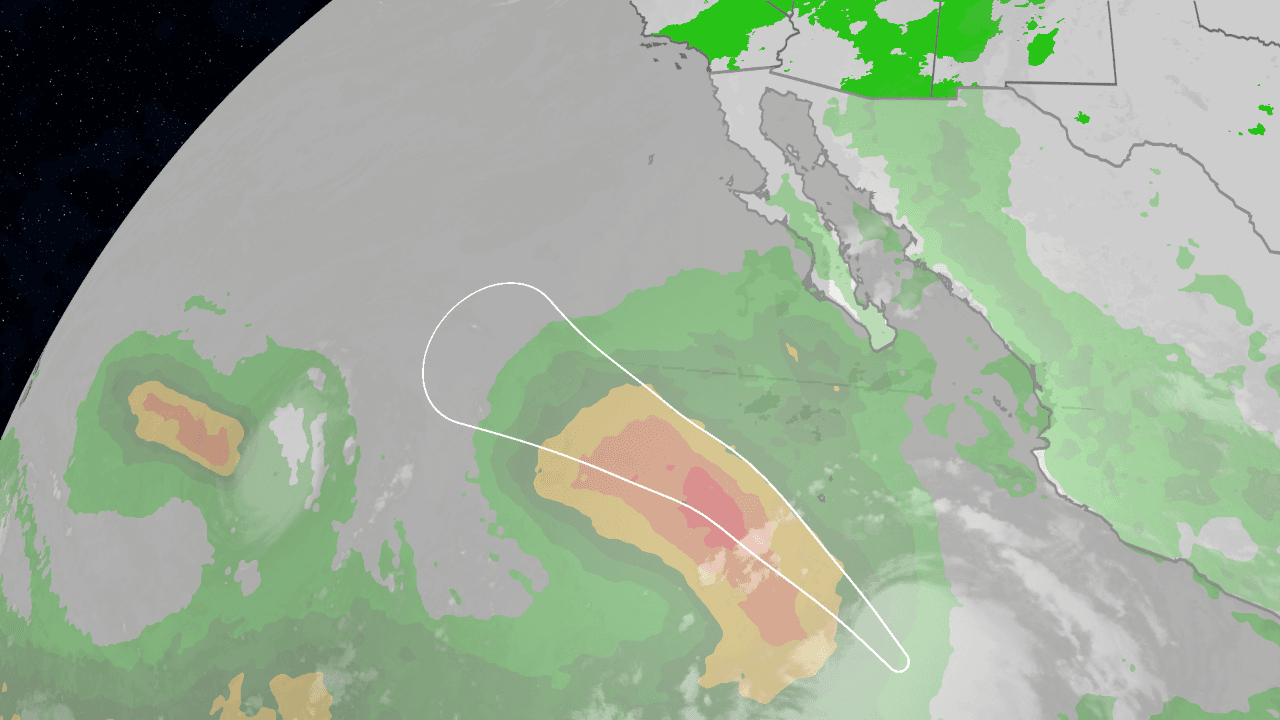
Marie’s track and timing
Tropical Storm Marie formed in the early hours of Tuesday, September 1, 2026, in the Pacific Ocean and was located about 760 kilometers southwest of Manzanillo, Colima, with maximum sustained winds of 75 km/h and gusts up to 95 km/h as it moved northwest at about 15 km/h.
The National Weather Service said in Los Angeles that there is a high chance of large waves and strong rip currents for Labor Day beachgoers, and it also said there is a moderate chance of light rain impacting holiday events and a low chance of moderate to heavy rain with flooding and thunderstorms.

CBS LA Chief Meteorologist Paul Deanno said, "Will [Marie] make landfall in Southern California? Very likely not," while also saying, "Will there be impacts in Southern California? Very likely yes."
In Mexico, the SMN forecast described Marie as potentially reaching Category 1 hurricane strength around midday on Wednesday, September 2, approximately 705 kilometers south-southwest of Cabo San Lucas, Baja California Sur, with the system expected to remain offshore as it strengthens and then gradually weakens.
The National Hurricane Center and SMN reported that as of the first advisory there were no coastal watches or warnings in effect for Marie, even as the storm’s circulation and swell were expected to affect conditions in Mexico’s western states.
Spaghetti models and uncertainty
ABC7 Los Angeles described "spaghetti models" as computer-generated tracks for where a tropical system such as a hurricane may go, saying the lines are spread out because there is still uncertainty in the forecast. The same ABC7 report said, "The more they are clustered together, the higher the confidence in the forecast," and it explained that dynamical models require hours on a supercomputer solving physical equations of motion while statistical models rely on historical relationships. MyNewsLA said the chances of Marie directly hitting Southern California as a hurricane or tropical storm remain "VERY LOW," while also stating that rain, high surf and other impacts were increasingly likely over the Labor Day weekend.
The Weather Channel said its forecast favored the scenario keeping Marie far from land, noting that "we're favoring the first scenario, keeping Marie far from land," while also describing a second model set that curls the storm on a more northerly path. In its discussion of the forecast cone, the New York Times said the map shows probabilities of at least 5 percent and that the forecast is for up to five days, starting up to three hours before the reported time that the storm reaches its latest location.

What could be at risk
For Southern California, ABC7 said Marie is forecasted to be strong enough to increase surf and rip currents for Labor Day weekend due to the large swell from tropical activity, and it tied the risk to the National Weather Service’s expectations for large waves and strong rip currents. MyNewsLA reported that evening high tides were expected to reach 6.5 to 6.8 feet Sunday and about 7 feet Monday, increasing the possibility of coastal flooding in low-lying areas and beach erosion, and it said moderate coastal flooding and beach erosion could occur if peak surf coincides with high tide. In Mexico, El Imparcial said Marie would bring rainfall of up to 50 mm to several states as it strengthens toward a Category 1 hurricane off the coast of Baja California Sur, while also stating that the system’s main concerns for the population were rainfall, surf, and related conditions rather than a direct landfall from the center.
“Future Hurricane Marie likely won't hit California. But there could be some impacts far from the storm.”
The Weather Channel said that even if Marie remains hundreds of miles away, California may still feel impacts including high surf, coastal flooding, and perhaps some thundershowers in the Los Angeles Basin over the holiday weekend. Across the forecast period, the New York Times said flash flooding can occur well inland and away from the storm’s center, emphasizing that even weaker storms can produce excessive rainfall that can flood low-lying areas.