Technology and Science19 July, 20263 min read
National Hurricane Center Issues Tropical Storm Watch for Florida Panhandle as Tropical Depression Two Forms
This article is an automated aggregation of coverage from news outlets. Our editorials offer in-depth analysis curated by the NewsCord team.
Tropical Depression Two formed in the northeastern Gulf of Mexico. A tropical storm watch is in effect for Florida's Panhandle.

TD Two Forms, Bertha Looms
A system in the Gulf was upgraded to Tropical Depression Two on Sunday, and the National Hurricane Center said a tropical storm watch was issued for the Florida Panhandle where there could be tropical storm conditions. NBC 6 South Florida said the depression is expected to gradually strengthen and that the rain will impact the I-10 corridor from the panhandle of Florida to Louisiana through at least midweek. The Sun Sentinel reported that Tropical Depression Two formed Sunday morning from a low-pressure system near Florida’s Gulf coast and was forecast to become Tropical Storm Bertha by late Sunday or early Monday.
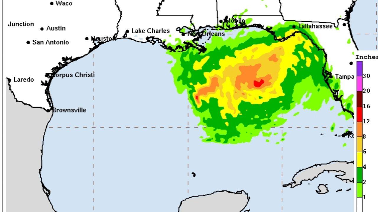
As of 2 p.m., the Sun Sentinel said the tropical depression was located about 170 miles south-southeast of Panama City, moving north-northwest at 1 mph, with maximum sustained winds of 30 mph. The Sun Sentinel also warned it could bring 1 to 3 feet of surge along Indian Pass to Chassahowitzka, Florida, and at least 2 to 4 inches of rain through Thursday along the eastern and central Gulf Coast.
Forecast Uncertainty and Data
Newsweek said NHC Deputy Director Jamie Rhome warned that Tropical Depression Two could form into Hurricane Bertha as it drifts slowly northward or northwestward over exceptionally warm waters, and he explained, "While there is a broad spin, there's an overall lack of deep thunderstorms." Newsweek also said an Air Force Reserve Hurricane Hunter aircraft is scheduled to investigate the disturbance Sunday afternoon to collect data on its organization and intensity. The Orlando Sentinel reported that as of the NHC’s 5 p.m. advisory, the center of TD 2 was located about 190 miles south-southeast of Panama City and was almost stationary with maximum sustained winds of 30 mph.
Orlando Sentinel added that forecasters expected a slow northwestward or north-northwestward motion for the next day or two, followed by a turn toward the west, and it cautioned, "there is a low amount of confidence given the uncertainty of how much land interaction will take place." The same Orlando Sentinel account said the forecast intensity shows it strengthening to 60 mph sustained winds by Wednesday morning and that tropical-storm conditions are possible within the watch area by late Monday.

Rain, Surge, and Preparedness
Forecasters emphasized that a system does not need to achieve hurricane strength to inflict severe damage, and Newsweek quoted AccuWeather lead hurricane expert Alex DaSilva saying, "Wind shear is expected to weaken across the northeastern Gulf this weekend into early next week." Newsweek also said the greatest potential impact stretches across four states and that forecasters were increasingly concerned about prolonged periods of torrential rain that could make localized flash flooding the primary threat. The Sun Sentinel specified that the system could bring at least 2 to 4 inches of rain through Thursday, with higher localized totals around 8 inches, and it said the track could move "near or along the northern Gulf coast during the next several days."
NBC 6 South Florida said regardless of strength, the rain will impact the I-10 corridor from the panhandle of Florida to Louisiana through at least midweek, while for South Florida residents it would mean watching for a few stray showers as drier air starts to work in. The Sun Sentinel reported that a tropical storm watch has been issued for Florida from the Ochlockonee River to the Alabama border and that an Air Force Reserve reconnaissance crew is set to investigate the tropical depression.